'Marking the Territory' is a series of posts which will physically mark boundaries of the various cities/forts/citadels of Delhi on
Open Street Map. The initial idea was to mark only the gates or locations of erstwhile gates of Shahjahanabad but I have extended it to marking pretty much all fort walls, gates etc which remain, can be traced or seen. It starts with Kashmere Gate and will hopefully extend to many more.
Location - Kashmere Gate -Delhi 6 (click
here for the map location)
Co-ordinates - N28 39.996 E77 13.746
Closest Metro Station - Kashmere Gate (Yellow Line)
Landmark - Near ISBT Kashmere Gate
Finding Kashmere gate, like most things in Delhi, is not easy. I started off at 7 in the morning, got into an auto and asked the auto driver 'Kashmere Gate?'. In today's parlance, it either stands for the big bus station or at best the locality around, which was part of the old walled city of Shahjahanabad. When I asked him if he knew about the old Kashmere Gate, after which the locality has been named, I drew a blank. 'The St. James' Church'? Blank again. So we decided we will reach the area and ask around. I had already given up the idea of asking for Kashmere Gate because it means too many things and unfortunately, they were not the same for me and for those answering. So, we settled for asking for the church. St. James' was an easy find. It was not even 8 when I reached and the church would not open till 8:30.
As I set off in one direction to look for Kashmere Gate, I was pondering on what line of enquiry should I take. I called a friend and requested him to check it up on the internet. Meanwhile, my line of enquiry started as 'Kashmere Gate?', changed to 'remnants of an old wall from the time of Mughals?', 'extension of red fort', 'a gate, an arched gateway'. I was directed towards Old Delhi railway station, was asked to walk past it. While Kashmere Gate was hard to come by, I saw this interesting looking mosque called 'Lal Masjid' (Red Mosque). It was red, on the first floor and had a variety of shops below it.
 |
| Lal Masjid in Kashmere Gate. I know nothing except the name. |
Finally, after a long circuituous route and multiple failed and semi-failed enquiries, I landed up at a place with a gate. An old morose looking caretaker had just let in a group of foreigners and was closing the gate. I asked 'Kashmere Gate?' 'Yes, the place this locality is named after' came the reply with the frown on the face replaced by a proud look and a gleaming smile. The place I was standing at was just 200 metres away from where I had started half and hour and 2 km ago.
 |
| Kashmere Gate! Finally!! |
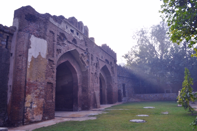
Kashmere Gate was built as part of the Red Fort walls by Shahjahan in 1638 AD. The northernmost gate of the walled city, it was so named because the road to the north led to Kashmir. While I have nothing to substantiate this, Shahjahan was so much in love with Kashmir that I dont find this far fetched. Any gate leading slightly to the north would have been christened such in those days. What remains now is a gate with a double archway, some barracks on the sides and some enclosures to house guards on duty. The wall encircling the old city is nowhere to be seen. Quite how much of what remains was part of the original structure is difficult to ascertain with the British and ASI restoration.
 |
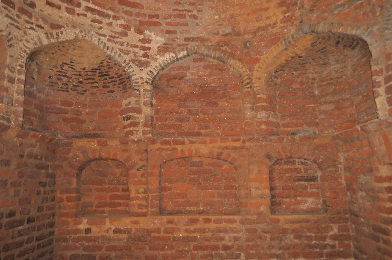
| The insides of the gates with niches. |
At a later stage, the gate played an important role in the mutiny of 1857, with a face off between the East India Company troops and the Indian rebels. As a result, the gate was extensively damaged, ostensibly from cannon balls fired by both parties. The damage can still be seen on the face of the structure, though a lot of it has been covered by the recent shoddy ASI restoration.
 |
| The back of the gate-clearly less restored than the front. The original damage is still visible. |
After the mutiny, Kashmere Gate served as a posh locality with British officer's quarters marking the area. With Lutyen's Delhi planned and executed, the area lost its importance, sheen and walls to time. What remains today is just a feeble reminder of what once was.
 |
| Part of the erstwhile barracks |


What are these; residential ares or something of the sorts, atop and next to the barracks??Do people live here?
ReplyDeleteI thought the gate was some national heritage kind of a structure, considering its history and the fact that it was built centuries ago!!
@Chandni - residential area and some shops all around it. The gate is 'national heritage' but is bounded by all sorts of other land use. Its been recently restored.
ReplyDelete